Visit Logged
  • Select Region
    • All Regions
    • VA to NC Line
    • North Carolina
    • South Carolina
    • Georgia
    • Eastern Florida
    • Western Florida
    • Florida Keys
    • Okeechobee Waterway
    • Northern Gulf
    • Bahamas
    • New York
    • Ohio
    • Pennsylvania
    • Washington
    • Puerto Rico
    • Minnesota
    • Maryland
    • Tennessee
    • NW Waters
    Order by:
    • LNM: Off WW, Situational Update – Hazardous Weather Outlook for the Western Atlantic – Thu Feb 5, 2026 14:00


      Situational Update – Hazardous Weather Outlook for the Western Atlantic


      united states coast guard

      The latest briefing for the western Atlantic is attached. This update covers the developing storm-force low over the southern waters tonight into Fri morning with winds over a small area up to 60 kt gusting to
      70 kt and seas building to 15-18 ft. Winds will increase to hurricane-force east of the waters Fri night into Sat. Another strong low will develop over the mid-Atlantic waters on Sat spreading storm-force winds over the waters east of the Carolinas.

      If there are any questions email ncep.opc.idss@noaa.gov

      The next scheduled briefing will be Friday, FEB 6, by noon EST or 1700 UTC.

      Thank you!


      This email was sent to curtis.hoff@CruisersNet.net using GovDelivery Communications Cloud on behalf of: U.S. Coast Guard · U.S. Department of Homeland Security · Washington, DC 20528 · 800-439-1420GovDelivery logo

      *** THIS DIV IS AUTOMATICALLY HIDDEN WHEN DISPLAYED – INFO FOR DEBUGGING PURPOSES ***
      ***MANUALLY DO: FIX TITLE, EXPIRE DATE, CATEGORIES, ENABLE SOCIAL POST ***
      0: llnr: 0 District: 07 lat/lon: 38.517803333333,-79.06959 Desc: Situational Update – Hazardous Weather Outlook for the Western Atlantic – Thu Feb 5, 2026 14:00

      WW: blat (33.87756) , blon (-78.52913) , bWWid (5) , bMM (339.0) , bDOffWW (322.0) , bAbbrev (AIWW) , bWWName (Atlantic Intracoastal Waterway.gpx)

      Be the first to comment!

    • LNM: Off AIWW MM:297.3, Upper Midnight Channel North Range Front Light Extinguished


      SAFETY/CAPE FEAR RIVER (CHART 11537)/ATON/SEC SNC BNM 0027-26


      united states coast guard

      UPPER MIDNIGHT CHANNEL NORTH RANGE FRONT LIGHT (LLNR 30675), AID REPORTED EXTINGUISHED.
      CANCEL AT//111540Z FEB 26//

      BT


      This email was sent to curtis.hoff@CruisersNet.net using GovDelivery Communications Cloud on behalf of: U.S. Coast Guard · U.S. Department of Homeland Security · Washington, DC 20528 · 800-439-1420GovDelivery logo

      *** THIS DIV IS AUTOMATICALLY HIDDEN WHEN DISPLAYED – INFO FOR DEBUGGING PURPOSES ***
      ***MANUALLY DO: FIX TITLE, EXPIRE DATE, CATEGORIES, ENABLE SOCIAL POST ***
      0: llnr: 30675 District: 05 lat/lon: 34.056362,-77.940385 Desc: Upper Midnight Channel North Range Front Light

      WW: blat (34.04843) , blon (-77.92626) , bWWid (5) , bMM (297.3) , bDOffWW (1.0) , bAbbrev (AIWW) , bWWName (Atlantic Intracoastal Waterway.gpx)

      Be the first to comment!

    • LNM: Off AIWW, Oregon Inlet Lighted Buoy 13 Relocated


      SAFETY/NC – OREGON INLET/ATON/CGD-E BNM 0050-26


      united states coast guard

      1. THE FOLLOWING AIDS TO NAVIGATION HAVE BEEN RELOCATED DUE TO SHOALING.
      A. OREGON INLET LIGHTED BUOY 12 (LLNR 28028) – RELOCATED TO APPROXIMATE POSITIION: 35-45-58.784N, 075-32-09.196W (35°45.9797N / 075°32.1533W, 35.766329 / -75.535888) .
      B. OREGON INLET LIGHTED BUOY 13 (LLNR 28045) – RELOCATED TO APPROXIMATE POSITIION: 35-45-55.567N, 075-32-08.776W (35°45.9261N / 075°32.1463W, 35.765435 / -75.535771) .
      CANCEL AT//181353Z FEB 26//

      BT


      This email was sent to curtis.hoff@CruisersNet.net using GovDelivery Communications Cloud on behalf of: U.S. Coast Guard · U.S. Department of Homeland Security · Washington, DC 20528 · 800-439-1420GovDelivery logo

      *** THIS DIV IS AUTOMATICALLY HIDDEN WHEN DISPLAYED – INFO FOR DEBUGGING PURPOSES ***
      ***MANUALLY DO: FIX TITLE, EXPIRE DATE, CATEGORIES, ENABLE SOCIAL POST ***
      0: llnr: 28028 District: 05 lat/lon: 35.767114,-75.535898 Desc: Oregon Inlet Lighted Buoy 12

      WW: blat (35.71422), blon (-76.01365), bWWid (5), bMM (97.5), bDOffWW (27.0), bAbbrev (AIWW), bWWName (Atlantic Intracoastal Waterway.gpx)

      1: llnr: 28045 District: 05 lat/lon: 35.766208,-75.535188 Desc: Oregon Inlet Lighted Buoy 13

      WW: blat (35.71325), blon (-76.01354), bWWid (5), bMM (97.5), bDOffWW (27.1), bAbbrev (AIWW), bWWName (Atlantic Intracoastal Waterway.gpx)

      Be the first to comment!

    • LNM: Off AIWW, Oregon Inlet Lighted Buoy 12 Relocated


      SAFETY/NC – OREGON INLET/ATON/CGD-E BNM 0050-26


      united states coast guard

      1. THE FOLLOWING AIDS TO NAVIGATION HAVE BEEN RELOCATED DUE TO SHOALING.
      A. OREGON INLET LIGHTED BUOY 12 (LLNR 28028) – RELOCATED TO APPROXIMATE POSITIION: 35-45-58.784N, 075-32-09.196W (35°45.9797N / 075°32.1533W, 35.766329 / -75.535888) .
      B. OREGON INLET LIGHTED BUOY 13 (LLNR 28045) – RELOCATED TO APPROXIMATE POSITIION: 35-45-55.567N, 075-32-08.776W (35°45.9261N / 075°32.1463W, 35.765435 / -75.535771) .
      CANCEL AT//181353Z FEB 26//

      BT


      This email was sent to curtis.hoff@CruisersNet.net using GovDelivery Communications Cloud on behalf of: U.S. Coast Guard · U.S. Department of Homeland Security · Washington, DC 20528 · 800-439-1420GovDelivery logo

      *** THIS DIV IS AUTOMATICALLY HIDDEN WHEN DISPLAYED – INFO FOR DEBUGGING PURPOSES ***
      ***MANUALLY DO: FIX TITLE, EXPIRE DATE, CATEGORIES, ENABLE SOCIAL POST ***
      0: llnr: 28028 District: 05 lat/lon: 35.767114,-75.535898 Desc: Oregon Inlet Lighted Buoy 12

      WW: blat (35.71422), blon (-76.01365), bWWid (5), bMM (97.5), bDOffWW (27.0), bAbbrev (AIWW), bWWName (Atlantic Intracoastal Waterway.gpx)

      Be the first to comment!

    • Researcher Annie Harshbarger reveals pilot whale behavior – Coastal Review

      Be the first to comment!

    • Hurricane-Force Warning West Atlantic – Fred Pickhardt

      Fred Pickhardt’s Substack is free today. But if you enjoyed this post, you can tell Fred Pickhardt’s Substack that their writing is valuable by pledging a future subscription. You won’t be charged unless they enable payments.


      Forwarded this email? Subscribe here for more

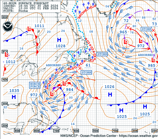
      A Hurricane Force Wind Warning has been issued for a rapidly intensifying low-pressure system in the western North Atlantic. The system is forecast to deepen significantly over 48 hours, reaching a peak intensity with storm to hurricane-force winds (50–65 KT) and seas up to 11 meters (36 feet) in 36 hours. The most severe conditions (50–60 KT winds and 13-meter (43 ft) seas expected by 48 hours within the SE, W, and N quadrants of the storm center, with gales extending out up to 720 nautical miles.


      NOAA High Seas Forecast

      NOAA Offshore Forecasts

      NOAA US Coastal Waters Forecasts

      Ocean Weather Services

      Forensic Marine Weather Expert

      See also “The Other Hurricane Season”


      You’re currently a free subscriber to Fred Pickhardt’s Substack. For the full experience, upgrade your subscription.

      Upgrade to paid

       
      Like
       
      Comment
       
      Restack


      © 2026 Fred Pickhardt
      548 Market Street PMB 72296, San Francisco, CA 94104
      Unsubscribe

      Get the appStart writing

      Be the first to comment!

    • Major East Coast Storm Update: Powerful Winter Storm Likely – Fred Pickhardt

      Fred Pickhardt’s Substack is free today. But if you enjoyed this post, you can tell Fred Pickhardt’s Substack that their writing is valuable by pledging a future subscription. You won’t be charged unless they enable payments.


      Forwarded this email? Subscribe here for more

      Major East Coast Storm Update:

      Powerful Winter Storm Likely


      Preview


      READ IN APP


      A powerful winter storm, forecast to intensify into a “bomb cyclone,” is expected to create dangerous marine conditions along the US East Coast and Western Atlantic from Saturday through Monday…

      User's avatar

      Continue reading this post for free in the Substack app

       
      Like
       
      Comment
       
      Restack


      © 2026 Fred Pickhardt
      548 Market Street PMB 72296, San Francisco, CA 94104
      Unsubscribe

      Get the appStart writing

      Be the first to comment!

    • Weather Alert (Jan 29): Snowstorm This Weekend – SCDNR


      South Carolina Department of Natural Resources color logo and white text of agency name and State Climatology Office

      Weather Alert  –  January 29, 2026

      Snowstorm This Weekend

      Key Points:

      • A snowstorm is likely to affect South Carolina Friday night through Saturday night. A Winter Storm Watch is in effect for the entire state.
      • Many areas may see light rain at the onset, and parts of the Coastal Plain may see up to a few hours of sleet and freezing rain. However, the risk for power outages will be low because significant ice buildup is unlikely, and the snow will be dry and fluffy.
      • Snow will start Friday evening in the Upstate and spread over the state through the night, reaching I-20 by around midnight and the Lowcountry around daybreak.
      • There remains uncertainty about how much snow will fall. However, the Catawba Region, the Pee Dee, and perhaps the Grand Strand will likely see the heaviest snowfall.
      • Snow will taper off from west to east on Sunday, ending by daybreak in the Upstate and by midday along the Grand Strand.
      • Winds will increase during the storm with peak gusts of 35-40 mph along the coast and around 30 mph elsewhere on Sunday. The wind will cause blowing and drifting snow where we see a substantial accumulation. The winds will also drive wind chills down to the single digits and teens over most of the state on Saturday through Sunday.
      • Roads will become slippery for a few days where substantial snow falls because it will remain cold behind the storm, resulting in slow daytime melting and nighttime refreezing. The extent and duration of potential travel problems are uncertain; it will depend on how much snow falls.

      It’s gonna snow this weekend, y’all, with impacts from the storm lingering into early next week. The only questions are how much, and who gets the heaviest.

      In the meantime:

      • A moisture-starved front in the area through tonight brings us some high clouds, but no rain or snow. Probably would have been snow with a better supply of moisture.
      • Clouds will increase on Friday into Friday night ahead of the approaching storm. Highs on Friday will range from the low 40s in the Upstate to the upper 50s in the far south.

      Uncertainty remains in the forecast, but there is more confidence than before. We can provide you with an accumulation forecast now; here’s what the National Weather Service (NWS) is calling for:

      The latest statewide snow accumulation map for South Carolina from the National Weather Service indicates heavy snow north of I-20.

      The current questions are about where the heaviest snow falls and how much we all see. The heaviest snow may fall over tomato-and-vinegar country instead of here, though it’s most likely that some of the heavy snow will affect the northern part of the state. The greatest uncertainty for snow amounts is over the Grand Strand and lower Pee Dee region; the ceiling is pretty high there, but the most likely scenario is relatively low. I just did a quick check before sending this out; it looks like the NWS is in the process of increasing the forecast snow for the Pee Dee region, so don’t be surprised to see the forecast for that area being bumped up.

      Storms like these sometimes cause oddities, such as a large difference in snowfall over a relatively short distance, due to small bands of heavy snow that often form. Don’t be surprised if what falls in your backyard varies a lot from what a buddy of yours 15 miles away sees.

      The primary impact will be slippery travel, since it’s going to be mainly dry, fluffy snow (parts of the coastal Plain might see a brief period of freezing rain that would make elevated roads slick like a muddy pig). Snow-covered roads will be a problem Saturday through Monday morning, and it’s going to remain cold behind this storm, so the roads could remain slick for a while. How hard it will become to get around and how long the roads remain bad will depend on how much snow falls. If you’re in an area that could see over three inches, start planning to avoid travel from Saturday through at least Monday. Areas to the south are likely to see lower impacts, but travel will be hazardous at least through Saturday and Sunday morning.

      Bundle up if you go out to play in the snow or if you must be out for work or an emergency; this is among the coldest snow events we’ve seen. The frigid winds will bring a bite, so layer up! Do check your pipes if you didn’t before the last storm to ensure that they’re properly insulated, because it will be at least as cold behind this storm as it was after the last one.

      What else can you do now? Check out SCEMD’s SC Winter Weather Guide and ready.gov for tips, and go from there.


      Frank Strait
      Severe Weather Liaison
      S.C. State Climate Office

      facebook
      instagram
      rss feed
      twitter
      youtube

      Be the first to comment!

    • New Climate Reports Show ‘Unprecedented Run of Global Heat’ – Inside Climate News (ICN)


      Be the first to comment!

    • Weather Alert (Jan 28): Snow Likely This Weekend – SCDNR


      South Carolina Department of Natural Resources color logo and white text of agency name and State Climatology Office

      Weather Alert  –  January 28, 2026

      Snow Likely This Weekend

      Key Points:

      • Confidence is increasing for most or all of South Carolina to see a snowstorm this weekend.
      • Mainly snow will fall, but many areas may see light rain at the onset, and parts of the Coastal Plain may see up to a few hours of sleet and freezing rain. However, the risk for power outages will be low because significant ice buildup is unlikely, and the snow will be dry and fluffy.
      • Snow amounts are in question, and it’s still too early to provide specifics. However, it’s likely that the Catawba Region, the Pee Dee, and the Grand Strand will see the heaviest snowfall and have the best chance of three inches or more.
      • The potential exists for slippery travel starting Friday night with snow falling through Saturday night. Roads may remain slippery for a few days where substantial snow falls because it will remain cold behind the storm, resulting in slow daytime melting and nighttime refreezing. The extent and duration of potential travel problems are uncertain.
      • Winds will increase during the storm with peak gusts of 35-40 mph along the Coastal Plain and around 30 mph elsewhere on Sunday. The wind will cause blowing and drifting snow where we see a substantial accumulation. The winds will also drive wind chills down to the teens over most of the state on Saturday through Sunday and to the single digits Sunday night.

      Another winter storm now looks likely for most or all of the state Saturday into Sunday. There is good computer model agreement that the storm will bring mainly snow, but they disagree on the amounts. Some show a major event with parts of the state seeing over six inches, while others show a peak of only a few inches.

      In the meantime:

      • We’ll remain dry ahead of the storm, but a moisture-starved cold front will move through tonight into Thursday. Highs on Thursday will range from the low 40s north to near 50 south.
      • Clouds will increase on Friday ahead of the approaching storm. Highs on Friday will range from the low 40s in the Upstate to the upper 50s in the far south.

      Uncertainties remain because of the complexity of the weather pattern over North America. The primary weather feature is moving southward from Hudson Bay today. It will cross the Great Lakes on Friday and reach the Tennessee Valley on Saturday. It will then move through the Carolinas and depart to the northeast on Saturday night into Sunday. Pacific disturbances now south of Alaska and west of Baja California may join with the storm and add moisture. However, the computer models could be off on the timing of those Pacific disturbances, and they may end up not becoming involved. More available moisture would lead to more snowfall.

      This annotated satellite map shows the features involved in this weekend's snowstorm and their possible tracks

      This annotated infrared satellite image shows the complexity of our current weather pattern that leads to the uncertainties with this weekend’s potential winter storm:

      • The track of the primary feature moving south from Hudson Bay is in question, and slight differences in its track could make a big difference in how severe the storm is for South Carolina.
      • We may see weather features currently over the Pacific pulled into the weekend storm, and this would result in more moisture available and a more energetic storm.
      • Other weather features not directly involved in the storm may still influence its behavior.

      Image Source: University of Wisconsin RealEarth

      However, the range of scenarios points to at least a little snow falling over some or all of South Carolina as early as Friday night. Some scenarios would lead to less moisture available, and some would result in the storm not really getting its act together until it’s moving away from us. Others show the storm intensifying by the time it gets here, bringing a major snowstorm that affects most of the state. The truth is somewhere in between, but the model trend over the last day has been toward more snow.

      You can expect different impacts from this storm than from this past weekend’s, since it’s likely to bring snow rather than thick ice. Also, the snow will be dry and fluffy because it will be so cold, and it won’t adhere well to trees or power lines, so the risk for power outages will be low. Slick roads will be a problem, and it’s going to remain cold behind this storm, so the roads could remain slick for a while. How hard it will become to get around and how long the roads remain bad will depend on how much snow falls. It’s too early to give specific accumulation numbers (that’s coming tomorrow), but the area east of I-77 and north of U.S. 378 has the best chance of heavy snow. If you’re in that area, start planning to avoid travel Saturday through at least Monday. The rest of the state is likely to see lower impacts, but travel will be hazardous at least on Saturday and Sunday.

      What else do you do now? Check out SCEMD’s SC Winter Weather Guide and ready.gov for tips, and go from there.

      An infographic giving ideas on how to prepare for a winter storm

      Frank Strait
      Severe Weather Liaison
      S.C. State Climate Office

      facebook
      instagram
      rss feed
      twitter
      youtube

      Be the first to comment!

    • Raising awareness of Outer Banks history on Eastern Shore – Coastal Review

      Be the first to comment!

    • Oriental NC Boat Show April 10-12, 2026, AICW Statute Mile 181

      Be the first to comment!

    • January 2026 OBX Park News: Looking Ahead


      Your January e-news preview:


      A Message From Our Director: Looking Ahead
      Dear Friends.

      As we begin a new year, I want to extend my deepest thanks to each of you for your extraordinary outpouring of generosity last month. Your support was truly record-setting as we wrapped up 2025, and it speaks volumes about how deeply members of our Outer Banks Forever community, near and far, care about our three Outer Banks national parks. Because of you, we are starting 2026 with renewed momentum, confidence, and optimism!

      Your generosity does more than fund individual park projects. It helps build the long-term capacity of Outer Banks Forever by strengthening our ability to have more impact on our national parks, take on more ambitious projects, and serve as an even stronger partner to the National Park Service. That kind of support is transformational. It allows us all to not only preserve what makes our national parks special today, but also to plan boldly for the future.

      And 2026 is shaping up to be a landmark year. We expect to complete the new bathhouse along the new pathway at the Cape Hatteras Lighthouse, an important improvement that will enhance the visitor experience at one of the most iconic sites on the Outer Banks. We also look forward to finishing the restoration of the Double Keepers’ Quarters at Bodie Island, which suffered significant internal damage from a fire in 2025. Seeing this historic structure brought back to life will be a powerful reminder of why fundraising efforts matter and what is possible when a community comes together.

      These milestones are just the beginning. We have many more plans for 2026: projects that will protect historic structures, improve visitor access, and deepen the connection people feel to these remarkable national parks. Thanks to your support, we are well positioned to turn those plans into reality.

      On a more personal note, I have thoroughly enjoyed the Outer Banks off-season. It has been a gift to spend time connecting with local businesses, meeting second-home owners, and getting to know even more people who make this place so special. The quieter months offer a chance to truly appreciate the strength, generosity, and pride of the Outer Banks community I am fortunate to call home.

      As we look ahead, I am excited for the return of spring and summer, when families and friends once again pour into the Outer Banks. They come to build memories, reconnect, and add new chapters to their personal stories, which are so often centered around this magical place we all love.

      Thank you for making our work possible. I cannot wait to see what we accomplish together in 2026!

      Happy New Year, and thank you again for your support!

      Bryan Burhans
      Director
      Outer Banks Forever
      PS: New year, new inbox! To ensure you continue receiving our monthly e-newsletters and other email communications, please add info@obxforever.org to your email address book or contact list if you haven’t already done so. For additional tips, click here
      Support Our Parks
       
      Wright Flight Academy: It’s Time to Celebrate!
      In the tenth installment of the Wright Flight Academy video series, current and former First Flight High School Aviation students celebrate the completion of their airplane — and the community members who made it possible — which is only the second aircraft built on the site of the first flight since December 17, 1903!

      We’re proud to support this program by sponsoring this video series created by Rayolight Productions. As additional videos become available, we’ll be adding them to our YouTube channel, sharing them on Facebook, and including them in our monthly e-newsletters.

      Learn More
       
      Donor Spotlight: Shannon Painter of Sun Realty
      We’d like to introduce you Shannon Painter, Vice President of Marketing and Communications at Sun Realty!

      Shannon (pictured center) grew up in Currituck on the Outer Banks and is passionate about introducing visitors to our three Outer Banks national parks. She and her team at Sun Realty have generously supported us and other great Outer Banks nonprofits through their annual Giving Tuesday campaign!

      Meet Shannon
       
      Stories From Our Parks: Sarah Freeman
      This content is brought to you by our National Park Service partners.
      The development of the Freedmen’s Colony of Roanoke Island was made possible through the dedicated efforts of missionaries who arrived on the island to assist the formerly enslaved people.

      Sarah Freeman was one of the tireless teachers of the Roanoke Island Freedmen’s Colony who worked to provide education to recently freed people. Working through adversity and hardship, she gave her life to other people in the hopes that they would have a better life through education and opportunity.

      Sarah’s story is featured as part of the Freedom Trail at Fort Raleigh National Historic Site on Roanoke Island, where life-sized silhouettes help bring these inspiring stories to life. On your next visit to Fort Raleigh, we encourage you to stop and reflect at the First Light of Freedom Memorialattend a ranger program, and explore the Freedom Trail to learn more about the freedom seekers who risked everything to find a safe haven and rebuild their lives on Roanoke Island during and after the Civil War, and how their stories and legacies continue to shape our community and our nation today. 
      Learn More
       
      New Year’s Resolution: Monthly Giving
      Looking to make a new year’s resolution you can keep? Consider monthly giving to Outer Banks Forever!

      Your monthly gift is automated, so all you have to do is set it up! Every gift, no matter the size, helps us protect and enhance Cape Hatteras National Seashore, Fort Raleigh National Historic Site, and Wright Brothers National Memorial, now and forever.

      Interested in monthly giving?

      Email Nicole Erickson, Development & Adoption Programs Manager, at nicoleerickson@obxforever.org for more information.
      Set Up a Gift
       
       
      Connect With Us!
      Facebook
      Link
      YouTube
      Website
      Email
       
      Copyright © 2026 Outer Banks Forever, All rights reserved.
      You are receiving this email because you opted in via our website. If you choose to unsubscribe, you will no longer receive any emails from us.

      Our mailing address is:

      Outer Banks Forever

      PO Box 1635

      Kill Devil Hills, NC 27948-1635

      Add us to your address book

      Want to change how you receive our emails?
      You can update your preferences or unsubscribe from this list.

      Email Marketing Powered by Mailchimp

      Be the first to comment!

    • An enormous climate blind spot – Inside Climate News (ICN)


      Be the first to comment!

    • Have you heard of Downtown Roots? Visit Edenton, NC [Albemarle Sound, NC]


      Edenton, NC - the prettiest town in the South!

      A longtime CRUISERS NET SPONSOR, historic Edenton always has an exciting calendar of events and places to visit! Edenton is at the mouth of the Chowan River on the northwest shore of Albemarle Sound.​


      Click Here To View the North Carolina Cruisers Net Marina Directory Listing For Edenton Harbor City Docks

      Click Here To Open A Chart View Window Zoomed To the Location of Edenton Harbor City Docks

      Be the first to comment!

    • Weekend Winter Storm Update – SCDNR


      South Carolina Department of Natural Resources color logo and white text of agency name and State Climatology Office

      Weather Alert  –  January 21, 2026

      Weekend Winter Storm Update

      Key Points:

      • A Winter Storm Watch is now in effect for much of northern South Carolina, including the Upstate, Catawba Region and Chesterfield County.

      A map showing the counties under a Winter Storm Watch, highlighted in blue

      A map showing the counties under a Winter Storm Watch, highlighted in blue

      • Confidence continues to increase that at least a part of South Carolina will be affected by a major, long-duration winter storm this weekend.
      • However, the storm’s forecast track has shifted northward, lessening potential impacts for areas along and south of I-20. Timing has changed as well, with the storm starting in the afternoon or evening on Saturday and lasting into early Monday.
      • The storm’s details, such as precipitation type, remain uncertain. Shifting computer model output will likely lead to more forecast changes.
      • Most likely scenario, not heavily favored due to uncertainty:
        • Snow, if any, and sleet in the Upstate starting on Saturday, will eventually turn to freezing rain. There may be a sleet accumulation into Saturday night, and a damaging ice buildup is possible on Sunday. Travel will be hazardous through at least Monday morning. Should there be a significant sleet accumulation, it would be slow to melt behind the storm as it remains cold.
        • Across the CSRA, the Midlands, and northern Pee Dee, freezing rain may dominate north of I-20, with a chance of damaging ice accumulation and slippery travel Saturday night into Sunday. Areas along and south of I-20 see freezing rain for a time, then rain as temperatures warm above freezing on Sunday.
        • Areas further south and east may see freezing rain for a time Saturday night, then rain Sunday. Elevated road surfaces could become icy for a time.
        • The Lowcountry and Grand Strand primarily see rain, though a period of freezing rain is possible at the onset, especially inland. Some models show it warming up enough on Sunday for thunderstorms.
      • Worst-case scenarios include:
        • A severe ice storm is possible where freezing rain is dominant; the best chance appears to be in the Upstate, the Catawba Region, and the northern CSRA and Midlands.
        • Continued northward shifts in the storm track would shift the potential for sleet accumulations out of South Carolina, but a damaging ice storm would still occur in the Upstate. Less of the state would be at risk for a damaging ice buildup.
        • A more southerly track of the storm would bring heavy snow and sleet back into South Carolina, with a damaging ice storm further south, as previously thought. This idea is looking increasingly unlikely. However, the warmer, further north computer models may not be handling this weekend’s cold-air damming, and temperatures may remain below freezing near I-20 longer than the models indicate, resulting in a significant ice buildup in that area.

      Good afternoon. A northward shift in the computer model guidance on the track of a winter storm for much of the nation changes the potential impacts here in South Carolina. 

      The forecast for now through Friday night remains unchanged:

      • We remain dry through most of tonight.
      • The next cold front will move in on Thursday, bringing light rain to the Upstate, possibly starting by daybreak in some areas.
      • Light rain is possible over much of the state Thursday night into Friday evening as this cold front slowly sinks southward.
      • Arctic air will filter into South Carolina behind this front starting Friday evening.

      Our next storm, currently approaching California, will reach us on Saturday. It has become unlikely that any significant snow will fall in the state (a little at the onset maybe), but sleet and freezing rain are likely to affect much of the state. The computer models continue to show a range of possibilities, but the trend has been our friend, showing less of the state experiencing significant impacts.

      It would be best to start your preparations soon if you’re in an area that still may be hit by a damaging ice storm and slippery travel. How do you deal with it? SCEMD’s SC Winter Weather Guide is a good starting point, and you can get more tips on winter storm preparedness at ready.gov. Pay close attention to the generator safety and kerosene and propane heater safety tips; carbon monoxide is quite the villain.

      The picture should get increasingly clearer over the next couple of days as we get closer to the event. Another update is coming on Thursday!

      An infographic on preparing for winter weather from NOAA


      Frank Strait
      Severe Weather Liaison
      S.C. State Climate Office

      facebook
      instagram
      rss feed
      twitter
      youtube

      This email was sent to curtis.hoff@cruisersnet.net using GovDelivery Communications Cloud on behalf of: South Carolina DNR ·1000 Assembly Street · Columbia, SC 29201


      Be the first to comment!

    • ‘Colonial Topsail’ event to celebrate America’s 250th – Coastal Review

      Be the first to comment!

    • Potential Winter Storm Sunday – SCDNR


      South Carolina Department of Natural Resources color logo and white text of agency name and State Climatology Office

      Weather Alert  –  January 15, 2026

      Potential Winter Storm Sunday

      Key Points:

      • Fresh cold air will trickle into South Carolina Saturday night, then a storm system will arrive early Sunday to bring precipitation. There’s a chance it’s cold enough for snow, at least at the end of the precipitation or on the northwestern part of the area that sees precipitation.
      • The latest computer model trends as of late Thursday evening are toward a mostly rain event, but it’s a close call and we’re not out of the woods yet. Models sometimes flip-flop, even within a couple of days of an event.

      I said y’all would probably be hearing from me again sooner rather than later, and here we go (now that Verizon has its act together and I can use 2-factor authentication to access the system that composes these … been trying to send y’all of these since Wednesday morning). I wanted to get something out now that I finally can, so enjoy this waiting for you when you wake up or something to read during the downtime of your graveyard shift.

      We’re at risk of seeing a winter storm on Sunday, though nothing is set in stone yet due to uncertainties.

      First, let me set the table for the potential Sunday snow dinner:

      • Winds are diminishing tonight, but aside from a bitterly cold morning, Friday won’t be as harsh as Thursday was.
      • Another cold front will move through late Friday night into Saturday morning, causing a period of light rain in the Upstate. It may be cold enough for snow north of Highway 11, but you’d have to be on a high spot for a chance at an accumulation.
      • Reinforcing cold moves in behind the front for Sunday, and the front will turn stationary along our coast late Saturday night.

      A forecast weather map from the Weather Prediction Center for Saturday evening shows a cold front moving through SC

      This Weather Prediction Center weather map for Saturday evening shows a cold front moving through South Carolina and precipitation breaking out along the Gulf Coast.

      Here are the uncertainties for Sunday’s storm:

      • We know a storm will track along the front, moving along the Gulf Coast and then along our coast late Saturday night through Sunday. However, the storm could track farther inland or farther offshore, which will affect where the heaviest precipitation falls.
      • The storm’s intensity is uncertain; a stronger storm would lead to more widespread and heavier precipitation.
      • We’re not sure how well the cold air will penetrate South Carolina; it may not be cold enough for snow in areas where significant precipitation falls.
      • Even if it snows, the storm will mostly occur during the daytime, which makes it harder for the snow to stick.

      To illustrate the point, here’s output from one of the computer models, the GEFS (Global Ensemble Forecast System). It’s an ensemble model based on our GFS model. The GFS is one of the ensemble members, and the other members are the same model run with 30 slightly altered inputs, for a total of 31 variations. That simulates potential input errors. It also allows us to see the range of possibilities with an upcoming weather event and to gauge how well the model is performing.

      An array of maps showing total snowfall through 7 a.m. Monday for each member of the 0Z Friday run of the GEFS

      Total snowfall to forecast hour ending at 7 a.m. Monday from the GEFS using weather observations from 7 p.m. Thursday as the model’s starting point.

      Image Source: WeatherBELL

      The late-breaking information is that the overnight model runs available as of 11:30 p.m. Thursday (my bedtime!) show more moisture available but less cold air, resulting in not much snow in the Palmetto State on Sunday. We’re not out of the woods yet, but this trend favors snow haters. We’ll have the rest of the overnight models available when we wake up Friday morning, and the next round of models will start trickling in by late morning.

      You can see that there is a wide range of possibilities, ranging from little or no snow in the state to a part of the state receiving a significant snowstorm. Also, this is just one model. There are also models from Canada, Europe, the United Kingdom, Japan, Korea, and others to consider, plus a few newfangled artificial intelligence-based models. Meteorologists spend a ton of time looking at computer model output!

      As we get closer to the event, we’ll be able to start nailing down more details. The picture usually steadily improves once we’re within 72 hours of the event, as we are now.

      But we can say that the risk is there. Also, chilly days behind the storm, should it come to pass, could mean it takes a couple of days for the snow to melt. So, you’ll want to think about getting ready. That does not imply a stampede toward the bread and milk aisles of your favorite grocery store (though if you need bread or milk, buy it; even if it doesn’t snow, it seems milk sandwiches are haute cuisine according to YouTube). Start by reviewing SCEMD’s SC Winter Weather Guide, see which preps fit your situation best, and go from there.


      Frank Strait
      Severe Weather Liaison
      S.C. State Climate Office

      facebook
      instagram
      rss feed
      twitter
      youtube

      This email was sent to curtis.hoff@cruisersnet.net using GovDelivery Communications Cloud on behalf of: South Carolina DNR ·1000 Assembly Street · Columbia, SC 29201

      Be the first to comment!

    • Eating Through Edenton vol. 1. Visit Edenton, NC [Albemarle Sound, NC]


      Edenton, NC - the prettiest town in the South!

      A longtime CRUISERS NET SPONSOR, historic Edenton always has an exciting calendar of events and places to visit! Edenton is at the mouth of the Chowan River on the northwest shore of Albemarle Sound.​


      Click Here To View the North Carolina Cruisers Net Marina Directory Listing For Edenton Harbor City Docks

      Click Here To Open A Chart View Window Zoomed To the Location of Edenton Harbor City Docks

      Be the first to comment!


    Social Media Auto Publish Powered By : XYZScripts.com